
If hiking is one of the reasons you travel, Cape Verde deserves a different kind of itinerary from the one built around beaches.
On the mountainous islands, old cobbled paths cross ridges, descend into cultivated valleys and connect settlements across terrain where a few kilometres can involve substantial changes in altitude. A morning can begin above a volcanic crater and finish among sugarcane and banana terraces. Elsewhere, the objective may be a summit at 2,829 metres, a mountain ridge above Santiago or a quiet trail through an island receiving comparatively few visitors.
The strongest hiking is concentrated on Santo Antão, Fogo, Santiago, São Nicolau and Brava, but they suit different trips.
Santo Antão has enough variety to justify several days devoted almost entirely to walking. Fogo may earn its place in an itinerary because of one defining climb. Santiago is easier to combine with history, towns and beaches. São Nicolau offers substantial mountain hiking with fewer visitors, while Brava adds another level of remoteness.
Access matters too. Santo Antão has no airport. Santiago does. Fogo and São Nicolau have domestic air connections, while Brava, like Santo Antão, must be reached by sea. Those differences can matter as much as the trails when you only have a week in Cape Verde.
Hiking in Cape Verde at a Glance
| Island | Best for | Representative hiking | Access |
|---|---|---|---|
| Santo Antão | A hiking-focused trip | Cova–Paul, Ponta do Sol–Cruzinha, Ribeira da Torre | Ferry via São Vicente |
| Fogo | Volcano hiking | Pico do Fogo, Chã das Caldeiras | Domestic flight or ferry |
| Santiago | Hiking within a varied trip | Serra Malagueta, Pico da Antónia / Rui Vaz | International airport |
| São Nicolau | Quieter mountain hiking | Monte Gordo, Juncalinho, Morro Alto | Regional airfield + ferry |
| Brava | Remote island walking | Fajã d’Água, Pico das Fontaínhas, Furna–Vinagre | Ferry only |
If walking will occupy most of your holiday, Santo Antão is the natural place to begin. If hiking is only one element of the trip, the answer becomes less automatic.
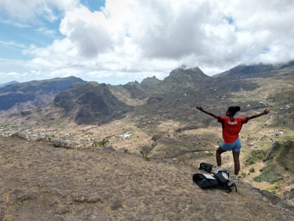
Is Cape Verde Good for Hiking?
Cape Verde’s best walking has little in common with the flat, purpose-built trail networks found in some hiking destinations.
Many routes pass through working landscapes.
A path may cross agricultural terraces, enter a village, follow an old cobbled road or descend through land still used to grow bananas, sugarcane, coffee, maize and other crops. On coastal routes, settlements and the Atlantic can remain visible for much of the day.
That gives hiking here a particular character: landscape and everyday life often occupy the same route.
The more mountainous islands also receive more rainfall than flatter islands such as Sal and Boa Vista, helping create the greener valleys associated with Santo Antão, Santiago, São Nicolau, Fogo and Brava.
Trail infrastructure is uneven.
Some well-known routes are straightforward for experienced independent hikers. Others have limited waymarking, multiple paths through inhabited or cultivated areas, exposed sections, or trailheads that are inconvenient to reach without organised transport.
Difficulty also needs to be judged by terrain rather than distance alone. Long descents over stone can be hard on the knees. Volcanic scree changes the character of a climb completely. A short route involving steep ascent may be harder than a considerably longer valley walk.
Santo Antão: The Best Island for a Hiking-Focused Trip
Santo Antão has the greatest concentration and variety of serious hiking in Cape Verde.
Deep valleys cut through the northern and northeastern mountains. Terraces climb steep slopes around Paul and Ribeira da Torre. Coastal paths link villages above the Atlantic, while the south and west of the island are much drier.
The result is not simply a collection of good trails. It is an island where several consecutive walking days can feel genuinely different from one another.
Official tourism information identifies routes including Cova–Paul, Cruzinha–Ponta do Sol, Ribeira da Torre–Corda, Ponta do Sol–Cruzinha and Tarrafal–Monte Trigo among the island’s hiking options.
Cova and Paul Valley
The Cova and Paul area is an excellent introduction to Santo Antão because several of the island’s defining landscapes appear within the same walking day.
High in the mountains, Cova is a volcanic crater whose floor is now cultivated. From the rim, routes descend towards Paul through steep slopes, settlements and agricultural terraces.
The landscape becomes progressively greener as altitude falls.
Bananas, sugarcane and other crops become more prominent, houses appear between fields and the route enters a valley shaped both by volcanic geology and generations of agriculture.
This is also one of the places where a guide can add more than navigation. Without context, you see terraces and crops. With someone local, those same features become part of the island’s economy, water use and traditions, including the sugarcane associated with Santo Antão’s grogue production.
The descent itself can be substantial. Several hours going downhill on cobbles can be tiring, particularly for the knees.
Ponta do Sol, Fontainhas and Cruzinha
The northern coastal trails offer a very different day.
The route between Ponta do Sol and Cruzinha, through the coastal landscape associated with Fontainhas and other small settlements, follows mountain terrain where the Atlantic remains a constant presence.
There are places where the slope drops sharply towards the sea and villages occupy terrain that appears improbable from across the valley.
This is not primarily a summit hike. The interest comes from travelling through the landscape on foot: the old path, settlements, agricultural plots, cliffs and changing views of the coast.
The route is also more exposed than the sheltered interior valleys. Hikers uncomfortable with heights should take that into account when choosing their walks.
The official Santo Antão tourism material lists the Cruzinha–Ponta do Sol circuit and the broader Ponta do Sol–Cruzinha route among the island’s principal trails.
Ribeira da Torre and the Mountain Interior
Ribeira da Torre introduces another part of Santo Antão’s hiking geography.
The valley is enclosed by steep rock walls and contains cultivated terraces and settlements beneath higher ridges. Walks here can stay within the valley or climb towards areas such as Corda.
The official tourism authority describes Ribeira da Torre–Corda as one of the island’s more demanding hikes.
That gives Santo Antão useful depth.
A traveller spending four or five walking days on the island does not need to repeat variations of Cova–Paul. Routes can be selected according to climbing, descent, exposure, coastal scenery or agricultural valleys.
One hike shows you Santo Antão. Several hikes show you how different Santo Antão can be.
Getting to Santo Antão
There is no functioning airport on Santo Antão.
For most international visitors, the practical route is to fly to São Vicente, travel to the port in Mindelo and take the ferry to Porto Novo. Current official transport information identifies Santo Antão as accessible only by sea and shows regular connections from São Vicente, with the crossing taking less than an hour on some services.
That extra connection is worth including in the itinerary from the beginning.
If you have only three nights in Cape Verde, reaching Santo Antão may consume too much of the trip. If hiking is one of the main reasons you are travelling, several nights on the island easily justify the transfer.
São Vicente and Santo Antão also combine naturally: Mindelo provides culture, restaurants and an international airport, while most of the serious walking happens across the channel.
Fogo: Hiking on an Active Volcanic Landscape
Hiking on Fogo revolves around a much more concentrated landscape.
Pico do Fogo reaches 2,829 metres, the highest point in Cape Verde, rising above Chã das Caldeiras inside the island’s enormous volcanic setting. Visit Cabo Verde
Black lava, volcanic ash, vineyards and settlements coexist within and around the caldera.
A hiking trip here can therefore be built around one major physical objective, or around easier walks that explore the volcanic landscape without reaching the summit.
Pico do Fogo
The climb to Pico do Fogo is one of Cape Verde’s most demanding well-known hikes.
Official tourism guidance places the summit hike at roughly four to six hours depending on physical condition, while other official material says the journey can take up to six hours.
The terrain is part of the difficulty.
This is not a gradual walk along a fertile valley. The ascent is steep, the volcanic surface can be loose and the altitude adds to the physical effort.
A local mountain guide should be part of the plan. The official Fogo page states that the ascent must be accompanied by a local mountain guide, while related official guidance notes that Pico do Fogo and Bordeira routes are not signposted.
We will cover guide arrangements, difficulty, preparation and exactly what to expect in a dedicated Pico do Fogo Hike article.
Chã das Caldeiras Without the Summit
Fogo is still worth walking if reaching the summit is not your objective.
A circular route around Chã das Caldeiras provides a less demanding way to experience lava fields, the caldera, volcanic agriculture and settlements beneath Pico do Fogo. Cape Verde’s tourism authority specifically presents this as a gentler alternative to the summit ascent.
This can be useful for groups with different levels of fitness.
One traveller may want the summit while another is more interested in exploring the caldera and understanding how vines and other crops are cultivated in volcanic soil.
Getting to Fogo
Fogo has a regional airfield at São Filipe, with domestic connections including flights from Santiago. The island is also connected by ferry.
That makes Fogo easier to insert into some itineraries than Santo Antão, particularly when the trip already includes Santiago.
The mountain itself is inland, however, so reaching the island is only the first part of the logistics. A hiking plan also needs transport to Chã das Caldeiras and, for the summit, coordination with a guide.
Santiago: Hiking Without Making the Whole Trip About Hiking
Santiago is the most useful option when you want genuine mountain walking but do not want every day of the trip to revolve around trails.
The same island contains Praia, Cidade Velha, agricultural districts, mountain landscapes and Tarrafal in the north.
A four- or five-night stay can therefore include a serious walking day in the mountains without giving up history, towns, markets or time by the sea.
Official tourism information identifies Pico da Antónia, Serra Malagueta, Ribeira da Barca and Calheta de São Miguel among Santiago’s walking areas.
Serra Malagueta
The Serra Malagueta Natural Park is one of Santiago’s principal mountain areas.
Ridges and valleys cut through an elevated landscape where vegetation and agricultural activity vary with altitude.
Several routes are possible, so a visit does not depend on completing one famous fixed trail.
That flexibility is useful in a broader island itinerary. A walking day can be included while travelling between the central or southern parts of Santiago and Tarrafal in the north.
Pico da Antónia and Rui Vaz
Pico da Antónia is Santiago’s highest point, with Rui Vaz providing access to a higher, greener part of the island.
The surrounding area offers a different Cape Verde from Praia or the coastal settlements: mountain roads, cultivated land and elevated views replace the denser urban environment of the capital.
A traveller could spend one day walking here, another exploring Cidade Velha and later continue north towards Tarrafal.
That pattern explains Santiago’s place in a hiking guide better than trying to compare an individual trail directly with Santo Antão.
Getting to Santiago
Santiago contains Nelson Mandela International Airport at Praia and is one of Cape Verde’s main transport hubs.
For travellers with limited time, that simplicity matters.
Someone landing directly on Santiago can add mountain walking without consuming another day on an inter-island connection. For a trip where hiking is important but not dominant, that can outweigh the greater trail variety available elsewhere.
São Nicolau: Mountain Hiking with Fewer Visitors
São Nicolau has a substantial walking landscape of its own.
Its best-known mountain area is Monte Gordo Natural Park, but hiking also extends towards villages, valleys and more remote eastern parts of the island.
Monte Gordo rises to about 1,300 metres, and official tourism information lists routes including Juncalinho, Carriçal–Juncalinho, East Coast–Morro Alto and Traversata Morro Alto.
Monte Gordo Natural Park
The mountain landscape around Monte Gordo is greener than much of the surrounding island.
Trails pass through vegetation and elevated terrain with views over valleys and the coast. The protected area is also important for native and endemic flora.
The experience is quieter than the most popular walking zones of Santo Antão, but this should not be mistaken for an absence of serious hiking.
The official trail list extends well beyond Monte Gordo, including connections between Ribeira Brava, Fajã, Cachaço, Juncalinho and coastal areas.
A few days here can therefore support more than a single mountain excursion.
Getting to São Nicolau
São Nicolau has the Preguiça regional airfield and domestic air connections, as well as maritime links.
Schedules deserve more attention than they would on Santiago or Sal, particularly if you are building a short multi-island itinerary.
The practical implication is simple: São Nicolau suits travellers prepared to organise the trip around the island rather than squeezing it between tightly timed connections.
Brava: Walking on a Small, Remote Island
Brava combines steep terrain, small settlements and an unusually compact island scale.
Official tourism information lists several pedestrian routes, including Nossa Senhora do Monte–Fajã d’Água, Mato Grande–Pico das Fontaínhas, Mato Grande–Chão de Aguada–Cachaço and Furna–Vinagre.
Towards Fajã d’Água
A route towards Fajã d’Água captures much of what makes Brava interesting on foot.
The island’s elevated interior gives way to steep valleys descending towards the coast, with settlements appearing across a landscape compressed into a relatively small area.
Fajã d’Água itself adds a coastal destination to the walk, including the natural pools for which the area is known.
Hiking on Brava is less about assembling a list of famous bucket-list trails and more about using footpaths to explore the island’s interior, villages and coast.
Getting to Brava
Brava has no airport and is accessible only by sea, generally through connections involving Fogo or Santiago. Official ferry information places it on the Sotavento route and notes that the crossing between Fogo and Brava can take less than an hour.
That adds another moving part to the itinerary.
For a traveller with five days in Cape Verde, it may be difficult to justify. For someone travelling slowly through Fogo and the southern islands, Brava becomes much easier to incorporate.
Can You Hike on the Other Cape Verde Islands?
Absolutely. The distinction is about how much of your trip you want hiking to occupy.
São Vicente
São Vicente is particularly useful if you want one substantial walk rather than several days of trekking.
Monte Verde, at 774 metres, is the island’s highest point, and official tourism information describes the ascent as steep and physically demanding.
The island also has shorter routes and coastal walking.
Because São Vicente has an international airport and Mindelo is a major cultural destination, it is easy to build one hiking day into a trip that was never intended to be a hiking holiday.
And if one day turns into several, Santo Antão is across the channel.
Sal, Boa Vista and Maio
These islands offer walking, coastal routes and open landscapes, but they do not provide the same concentration of mountainous terrain.
That can be useful rather than limiting.
A multi-island trip could devote several physically demanding days to Santo Antão or Fogo and finish with beach time and easier walking on Sal or Boa Vista.
There is no need for every island in the itinerary to perform the same job.
When Is the Best Time for Hiking in Cape Verde?
The Cape Verde tourism authority recommends October to May as the best period for hiking and trekking.
The broader dry season generally runs from November to July, while most rainfall occurs between August and October.
Those months influence the landscape as well as comfort.
Rain can turn the mountain islands greener, particularly after the wettest period, but recent rainfall may also make cobbled paths, earth trails and steep descents more slippery.
At higher altitude, temperatures can feel considerably cooler than at the coast, particularly when wind or cloud moves across the mountains.
Between December and February, Cabo Verde can also experience the Harmatão, or dry Saharan haze, which may reduce visibility. Its intensity varies from year to year.
For detailed seasonal planning, our Best Time to Visit Cape Verde guide covers the climate more broadly.
For hiking, there is another rule worth keeping: check the conditions for the route you intend to walk, not just the monthly climate average.
Do You Need a Guide for Hiking in Cape Verde?
The answer depends on the trail, but there are three separate reasons to consider one.
Navigation
Not every Cape Verde trail has consistent signs or a single obvious line.
Pico do Fogo and Bordeira are explicitly identified by official tourism guidance as routes that are not signposted:
On other islands, paths may cross agricultural areas, split near settlements or use old local routes that are obvious to residents but less clear to visitors.
Experienced hikers may be comfortable navigating some popular routes independently. Remote or unfamiliar terrain deserves a different calculation.
Logistics
This is often the less glamorous problem, but one of the most important.
Many excellent walks are point-to-point.
You may start high in the mountains and finish kilometres away in another valley or town. Reaching the starting point at the right time and finding transport from the end can take more planning than the hike itself.
A guide, driver or organised hiking tour can remove that uncertainty.
It can also allow a route to be chosen according to the weather and local conditions that morning rather than locking the entire trip to a plan made months before.
Local context
A good hiking guide does more than prevent wrong turns.
In Paul or Ribeira da Torre, the route crosses a working agricultural landscape. On Fogo, geology sits alongside vineyards and settlements rebuilt around volcanic activity. In villages along the northern coast of Santo Antão, the path itself forms part of the relationship between communities and difficult terrain.
Someone who understands those places can explain what you are walking through rather than merely where to turn left.
For travellers who already enjoy hiking independently, this can be the strongest reason to spend at least one day with a local guide.
Planning a Hiking Trip to Cape Verde?
The best hiking itinerary depends on more than the name of the trail.
How many days do you want to walk? Are you comfortable with steep descents or exposed coastal paths? Do you want hiking to dominate the trip, or would one mountain day be enough? And how much inter-island travel are you willing to add?
Our local team can help organise the practical side: the right island, accommodation near the walking areas, local guides, trailhead and return transport, and connections between islands.
That can mean several hiking days across Santo Antão, a guided ascent of Pico do Fogo or a broader Cape Verde itinerary with one or two carefully chosen walks.
What Should You Bring for Hiking in Cape Verde?
Most classic Cape Verde hikes do not require expedition equipment.
They do require more preparation than a beach packing list.
Bring:
- hiking shoes or boots with reliable grip;
- enough water for the route, with extra capacity for exposed sections;
- sun protection, including sunscreen and a hat;
- light, breathable clothing;
- a warmer or wind-resistant layer for higher ground;
- snacks when food stops are uncertain;
- offline route information if walking independently;
- some cash for transport, cafés or local purchases.
Official tourism guidance for nature activities specifically recommends hydration, sun protection and appropriate footwear.
Trekking poles can also be useful on the long cobbled descents of Santo Antão, even for hikers who rarely use them on level terrain.
For Pico do Fogo, sturdy hiking footwear becomes more important because of the steep volcanic surface.
How Much Hiking Do You Want in Your Cape Verde Trip?
This is probably the most useful way to decide between the islands.
Hiking is the main purpose of the trip
Start with Santo Antão.
A stay of several nights allows you to combine valleys, coastal paths and more demanding mountain routes without repeating the same terrain every day.
The extra ferry connection via São Vicente becomes part of the itinerary rather than an inconvenience to minimise.
You want one defining hike
Fogo is difficult to ignore.
Pico do Fogo can justify travelling to the island even if the rest of the trip is not organised around trekking.
Allow enough time for Chã das Caldeiras rather than treating the climb as a quick excursion squeezed between flights.
You want one or two hiking days inside a broader holiday
Santiago offers the easiest balance.
Mountain walking can sit alongside Praia, Cidade Velha, Tarrafal and the rest of the island without requiring another inter-island transfer.
São Vicente can play a similar role on a smaller scale if Mindelo is already part of the trip.
You actively prefer quieter hiking islands
Look more closely at São Nicolau and Brava.
Both require more deliberate itinerary planning than Santiago, and Brava adds a sea connection, but neither should be treated merely as a substitute for Santo Antão.
Their routes belong to different trips.
Planning a Hiking Trip to Cape Verde?
The best hiking itinerary depends on more than the name of the trail.
How many days do you want to walk? Are you comfortable with steep descents or exposed coastal paths? Do you want hiking to dominate the trip, or would one mountain day be enough? And how much inter-island travel are you willing to add?
Our local team can help organise the practical side: the right island, accommodation near the walking areas, local guides, trailhead and return transport, and connections between islands.
That can mean several hiking days across Santo Antão, a guided ascent of Pico do Fogo or a broader Cape Verde itinerary with one or two carefully chosen walks.