
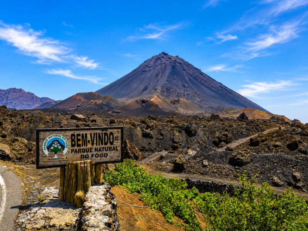
The Pico do Fogo hike reaches the highest point in Cape Verde at 2,829 metres.
The standard route is a steep mountain hike on loose volcanic terrain, with roughly 1,100 metres of ascent from Chã das Caldeiras.
Most summit days begin inside the caldera at around 1,700 metres above sea level.
From there, you cross the volcanic landscape before climbing the main cone through increasingly steep ash, rock and scoria.
The main difficulty comes from the sustained climb, unstable volcanic surface and rapid descent through loose ash.
For planning, allow around 5–6 hours of walking for a standard summit day. Faster groups may finish earlier, while slower groups, longer stops or route extensions can make the day longer.
The distance matters less here than the vertical gain.
A route of only around 8–10 kilometres can still feel like a serious mountain day when more than 1,000 vertical metres are concentrated into a steep volcanic cone.
Pico do Fogo Hike at a Glance
Summit: 2,829 m
Starting area: Chã das Caldeiras
Starting altitude: around 1,700 m
Elevation gain: approximately 1,050–1,100 m
Typical distance: route varies; around 8–10 km on commonly published summit routes
Walking time: plan around 5–6 hours; faster or extended routes can vary
Typical ascent: around 3–4 hours
Difficulty: Challenging
Terrain: volcanic ash, loose scoria, rock and hardened lava
Shade: virtually none on the main cone
Guide: plan to hike with a local mountain guide
Best start: early morning
Main physical challenge: sustained ascent on loose terrain
Main descent challenge: balance, knees and ankles on volcanic ash and scree
Alternative: Pico Pequeno and the Chã das Caldeiras lava fields
For the wider island, see our Things to Do in Fogo and Fogo Travel Guide.
How Difficult Is the Pico do Fogo Hike?
Pico do Fogo is a challenging mountain hike.
The standard route is a steep hiking route rather than a technical climb. Normal summit days use hiking equipment, although rocky sections may require your hands for balance.
The main requirement is enough fitness for a sustained climb of roughly 1,100 vertical metres.
The surface makes the effort harder.
Loose volcanic material shifts under each step, so progress on the steeper slopes is slower than it would be on a firm mountain path.
Someone who can comfortably walk 15 kilometres on flat ground may still find Pico do Fogo demanding.
A more useful comparison is a mountain day involving:
- more than 1,000 m of ascent;
- several hours of continuous uphill walking;
- loose volcanic ground;
- strong sun and almost no shade;
- a fast descent on unstable terrain;
- a summit above 2,800 m.
Fitness matters more than speed.
A steady pace is far more effective than climbing too quickly during the first hour.
The Elevation Gain Matters More Than the Distance
GPS tracks do not all show the same distance for Pico do Fogo.
That is normal.
The final figure depends on where the track starts in Chã das Caldeiras, how the guide approaches the main cone and which line is used for the descent.
Commonly published summit routes often fall somewhere around 8–10 km, although shorter and longer tracks also exist.
The more consistent number is the vertical gain.
From a starting altitude around 1,700 metres to the 2,829-metre summit, you gain roughly 1,100 metres.
That is the more useful figure when deciding whether the hike suits your fitness.
The Route from Chã das Caldeiras
The standard summit day begins in Chã das Caldeiras, inside the volcanic caldera.
The exact line varies according to current conditions and the guide, but the climb can be understood in several stages.
Crossing the Caldera
The opening section gives your legs time to warm up.
You move through the volcanic landscape of Chã with the main cone rising directly ahead.
Depending on the chosen route, the approach can cross hardened lava, ash and cultivated areas before reaching the steeper slopes.
From the caldera floor, the cone still rises roughly 1,100 vertical metres.
Reaching the Main Cone
The gradient increases as you approach the base of Pico do Fogo.
Underfoot, the terrain becomes progressively looser.
Small stones, volcanic gravel and ash reduce traction and make each step require more effort.
Short steps and a steady rhythm are generally more efficient than trying to gain height quickly.
The Steep Upper Slopes
This is the hardest part of the ascent for most hikers.
The route climbs directly through steep volcanic terrain with almost no shade.
Progress can feel slow because the surface moves beneath your boots.
Some rocky sections may require your hands for balance.
Your guide can adjust the line according to current conditions and the ability of the group.
The Summit and Crater
At 2,829 metres, you reach the highest point in Cape Verde.
On a clear day, the summit opens views across the caldera, the Bordeira, the rest of Fogo and the Atlantic.
Visibility beyond the island depends on atmospheric conditions.
The summit is exposed.
Wind, cloud and temperature can be very different from conditions in Chã das Caldeiras below, so the length of the summit stop depends on the weather.
The Descent Is a Major Part of the Experience
The descent from Pico do Fogo is usually much faster than the climb.
Guides commonly use loose volcanic slopes where hikers descend through ash and scoria in a controlled sliding motion.
Each step sinks or moves downhill.
Once the technique feels natural, progress can be surprisingly quick.
The descent still requires concentration.
Loose terrain affects balance and creates repeated strain on knees, quadriceps and ankles.
If long descents normally affect your knees, include that in your decision about the summit.
Walking poles can help with balance, although your guide may advise how best to use them on the loose slope.
Light gaiters can also be useful because fine volcanic material easily enters hiking shoes.
Keep a controlled pace even when the loose ash makes the descent feel fast.
Follow your guide’s line and leave enough space between hikers to reduce the risk of sending loose stones towards the person below.
How Long Does the Pico do Fogo Hike Take?
For most visitors, around 5–6 hours is a useful planning figure for the summit hike itself.
A common day may involve:
around 3–4 hours climbing
a short summit stop
a considerably faster descent
Actual duration depends on:
- fitness;
- pace;
- number of stops;
- size of the group;
- wind and visibility;
- condition of the volcanic surface;
- exact starting point;
- descent route;
- whether another section is added.
A steady five- or six-hour hike can be entirely appropriate.
The important point is to maintain a pace you can sustain through both the ascent and descent.
Start Early
An early start makes the climb easier to manage.
Temperatures are usually cooler.
You reduce the amount of climbing under the strongest part of the day’s sun.
There is also more time available if the ascent takes longer than expected.
Many guided climbs leave Chã das Caldeiras around sunrise or earlier.
If you start before daylight, carry a headlamp and keep it easy to reach.
An early departure is one of the strongest arguments for spending the previous night inside Chã das Caldeiras.
Climb with a Local Mountain Guide
Plan the Pico do Fogo hike with a local mountain guide from Chã das Caldeiras.
Cape Verde’s official tourism guidance says the ascent should be accompanied by a local mountain guide.
The value extends far beyond navigation.
A good guide knows:
- current conditions on the cone;
- the most suitable ascent line;
- the safest descent for the group;
- changes in weather and visibility;
- the volcanic landscape;
- the history of previous eruptions;
- the communities of Chã das Caldeiras;
- when conditions or a hiker’s physical state justify turning back.
The route crosses an active volcanic landscape where erosion, loose material and weather can alter the best line.
A downloaded GPS track can be useful as a backup, but current local knowledge is much more important.
Hiring locally also keeps part of the economic value of the hike within the community living in the caldera.
We can organise a local mountain guide, accommodation in Chã das Caldeiras, transfers and the wider Fogo itinerary around your summit day.
What to Wear
Footwear is the most important choice.
Use proper hiking shoes or boots with good grip.
The route combines sharp volcanic rock with fine ash and loose scoria.
Light trainers can become uncomfortable and unstable once the terrain steepens.
Dress in layers.
A practical combination includes:
- lightweight hiking clothes;
- an extra warm layer;
- windproof jacket;
- sun hat;
- sunglasses.
Conditions at the summit can be cooler and windier than in Chã das Caldeiras.
Dress for the whole mountain rather than only for the temperature outside your accommodation at departure.
What to Carry
For a normal summit day, consider:
- enough water for 5–6+ hours of exposed hiking;
- energy snacks or light food;
- sunscreen;
- sunglasses;
- extra warm layer;
- windproof jacket;
- headlamp for a pre-dawn start;
- small first-aid kit;
- walking poles if useful for your knees or balance;
- optional gaiters for volcanic ash;
- phone with offline maps;
- charged battery or power bank.
There are no shops halfway up the cone.
Prepare before leaving Chã.
Water needs vary according to temperature, body size and pace, but this is an exposed hike with very little shade. Discuss the amount with your guide according to the day’s conditions.
Also check that your travel insurance covers guided hiking up to 2,829 metres and does not exclude mountain or volcanic activities relevant to your planned trip.
Sun and Heat Add to the Effort
The main cone is highly exposed.
Once the sun rises, there is very little protection from direct sunlight.
The same ascent can therefore feel much harder when started later in the morning.
Use sunscreen even if the day begins cool.
A hat and sunglasses are useful throughout the climb.
Starting early also reduces the amount of water and energy lost to heat.
Altitude at 2,829 Metres
At 2,829 metres, some hikers may notice the effects of altitude.
You climb from around 1,700 metres to the summit over only a few hours.
Possible symptoms include headache, dizziness, nausea or unusual fatigue.
Fitness does not protect against altitude symptoms.
Tell your guide if you begin to feel unwell. Stop ascending if symptoms develop and descend if they become worse.
Because Pico do Fogo is normally climbed as a day hike followed by a return to lower altitude, exposure is much shorter than on a multi-day high-altitude trek.
Travellers with relevant medical conditions should seek appropriate medical advice before undertaking a strenuous mountain hike.
Best Time of Year for the Pico do Fogo Hike
The summit can be attempted during much of the year when local conditions permit.
The drier part of the year generally provides more predictable trail conditions.
During wetter periods, rain, cloud and road conditions can affect both access to Chã das Caldeiras and the climb itself.
Season matters, but conditions on the actual day matter more.
Before the hike, check:
- weather forecast;
- wind;
- cloud around the summit;
- recent rain;
- road access to Chã das Caldeiras;
- current advice from your guide or Parque Natural do Fogo.
Because Pico do Fogo is an active volcano, current official and local access information always takes priority over an older travel article or GPX track.
Stay in Chã das Caldeiras before the Hike
For the simplest summit day, stay in Chã das Caldeiras the night before.
This gives you:
- an early start without a long road transfer;
- more sleep;
- direct contact with your guide;
- time to confirm weather and route conditions;
- a quiet evening inside the caldera.
It also separates the summit day from the road journey between São Filipe and Chã.
After the hike, you can have lunch, rest, walk through the villages or add a wine experience instead of immediately returning to the coast.
See Things to Do in Fogo for other experiences around Chã das Caldeiras.
Hiking from São Filipe on the Same Day
It is also possible to stay in São Filipe and travel to Chã das Caldeiras for the hike.
In normal conditions, a private road transfer commonly takes around one to one and a half hours each way.
For an early summit start, that means leaving São Filipe well before sunrise.
This option works when changing accommodation is inconvenient, but it makes the overall day considerably longer.
The complete day becomes:
São Filipe → Chã das Caldeiras → summit hike → recovery or lunch → São Filipe
For most travellers who place the summit high on their priorities, one night in Chã makes the logistics easier.
For complete island transport and accommodation planning, see our Fogo Travel Guide.
Can You Combine Pico do Fogo and Pico Pequeno?
Some summit days can be extended towards Pico Pequeno and the newer lava landscapes.
This creates a longer day with more time in the volcanic terrain.
Whether the combination makes sense depends on:
- your pace after the summit;
- weather;
- remaining daylight;
- energy levels;
- current route conditions;
- the descent planned by your guide.
After more than 1,000 metres of climbing, assess the extension according to how you actually feel rather than how close Pico Pequeno appears on a map.
Travellers with an extra day can visit Pico Pequeno separately and enjoy the landscape at a slower pace.
Choosing the Summit or a Shorter Volcanic Hike
The summit suits hikers who can sustain several hours of uphill walking, are comfortable on loose ground and have previous experience with significant elevation gain.
The descent matters as well.
Sensitive knees, poor balance or discomfort on unstable slopes can make Pico Pequeno or a lava-field walk the better choice.
A shorter route can also be preferable when:
- you rarely hike in the mountains;
- you are recovering from injury;
- weather on the cone is poor;
- your available time is limited;
- another person in your group prefers a shorter day.
Pico Pequeno and the 2014–15 lava fields still provide close contact with Fogo’s volcanic landscape without the full 1,100-metre ascent.
Chã das Caldeiras remains the core volcanic experience either way.
Current Volcano and Trail Conditions
Pico do Fogo is an active volcano.
The Parque Natural do Fogo protects the main cone, caldera, Bordeira and surrounding landscapes.
Access and trail conditions can change because of weather, erosion, road issues or volcanic monitoring.
Check current information shortly before the climb instead of relying only on an older blog post or GPS track.
Your local guide should confirm the route and conditions before departure.
If authorities or park staff restrict access, postpone the summit.
After the Hike
Leave some space in the day after returning to Chã das Caldeiras.
Food, water and time off your feet will probably be more appealing than another demanding activity.
A local lunch fits naturally after the hike.
Fogo wine is another part of the Chã experience, but keep the tasting for after the mountain.
If you are staying overnight, the afternoon can remain light.
The summit already provides a complete mountain day.
Build the Hike into a Fogo Itinerary
A good Fogo itinerary gives the summit its own day.
For example:
Previous afternoon
Travel to Chã das Caldeiras, settle into your accommodation, meet your guide and confirm current conditions.
Summit morning
Start early, climb Pico do Fogo and return to Chã.
Afternoon
Have lunch, rest, take a short village walk or add a wine experience.
Following day
Return towards São Filipe, continue to Mosteiros or use the day for a wider island circuit.
This structure also creates flexibility.
If conditions are poor on the planned summit morning, another activity may be moved forward while the hike waits for a better weather window.
See Things to Do in Fogo for the rest of the island.
Combining Pico do Fogo with Santo Antão Hiking
Pico do Fogo gives you one concentrated summit challenge: a steep volcanic ascent with roughly 1,100 metres of elevation gain.
Santo Antão offers a broader network of valley, coastal and mountain walks through agricultural terraces and rural communities.
Travellers building a hiking-focused Cape Verde itinerary can combine both islands for two complementary types of walking.
See Best Hikes in Santo Antão and Hiking in Cape Verde to compare the options.
Getting to Fogo
Most travellers reach Fogo through São Filipe.
From there, continue by road to Chã das Caldeiras for the summit hike.
See Domestic Flights in Cape Verde for current inter-island flight planning.
If Fogo forms part of a route involving Santiago or Brava by sea, see Cape Verde Ferries.
For the complete island picture, including where to stay and how many days to allow, see our Fogo Travel Guide.
Plan Your Pico do Fogo Hike
A successful summit day begins before the climb itself.
Choose the right accommodation.
Arrange your local guide.
Confirm transport.
Check the weather and current conditions.
Start early.
Carry enough water and suitable clothing.
Then climb at a pace you can sustain.
Tell us:
- your travel dates;
- number of nights on Fogo;
- previous hiking experience;
- typical hiking duration;
- experience with 1,000 m+ elevation gain;
- whether steep descents affect your knees;
- whether you want to stay in Chã das Caldeiras;
- number of travellers;
- whether you want to combine the summit with wine, Pico Pequeno or other Fogo experiences.
We can organise accommodation, transfers to Chã das Caldeiras, a local mountain guide, the Pico do Fogo summit hike and the rest of your Fogo itinerary.