
Santo Antão is Cape Verde’s great hiking island.
Deep green valleys cut through volcanic mountains in the northeast, old stone paths connect villages across steep slopes, agricultural terraces climb the hillsides, and coastal trails run high above the Atlantic.
The western side of the island brings another landscape: drier volcanic plateaus, remote settlements and Santo Antão’s highest summit, Topo da Coroa.
The best hike depends on the experience you want.
Cova to Paul is the classic mountain-to-valley descent.
Ponta do Sol to Cruzinha via Fontainhas gives you Santo Antão’s most dramatic coastal walking.
Ribeira da Torre and Xôxô combine mountain scenery with one of the island’s greenest valleys.
Pico da Cruz towards Ribeira de Janela adds highland vegetation, forest and ocean views.
Topo da Coroa takes you into the dry western highlands for a more remote summit day.
The routes below are organised for planning rather than as a strict ranking. Two or three well-chosen hikes can already make an excellent Santo Antão trip, while extra days create space for shorter walks, slower valley days and changes according to weather or trail conditions.
Best Santo Antão Hikes at a Glance
| Hike | Planning distance | Walking time | Difficulty | Best for |
|---|---|---|---|---|
| Cova → Cabo de Ribeira / Paul | ~5–6 km official section; longer variants available | ~2.5–5 h | Moderate | First Santo Antão hike, terraces, agriculture |
| Ponta do Sol → Fontainhas → Cruzinha | ~14–15 km | ~6 h | Moderate, exposed | Coastal cliffs and villages |
| Ponta do Sol → Fontainhas return | ~5 km | ~2 h | Easy–moderate | Short scenic coastal hike |
| Pedra Rachada → Xôxô | ~6 km | ~3 h | Moderate | Highlands and Ribeira da Torre |
| Pico da Cruz → Ribeira de Janela / Penedo | ~9 km | ~3–3.5 h | Moderate | Highland vegetation and ocean views |
| Boca de Ambas Ribeiras → Chã de Igreja | ~8 km | ~4–4.5 h | Moderate | Rural valleys and quieter trails |
| Topo da Coroa from Chã de Feijoal area | route varies; ~12–15 km return common | ~5–6+ h | Difficult | Remote summit terrain |
Distances and walking times are planning references.
Trail names and measurements can vary between maps and hiking sources because some include approach roads, extensions or slightly different endpoints.
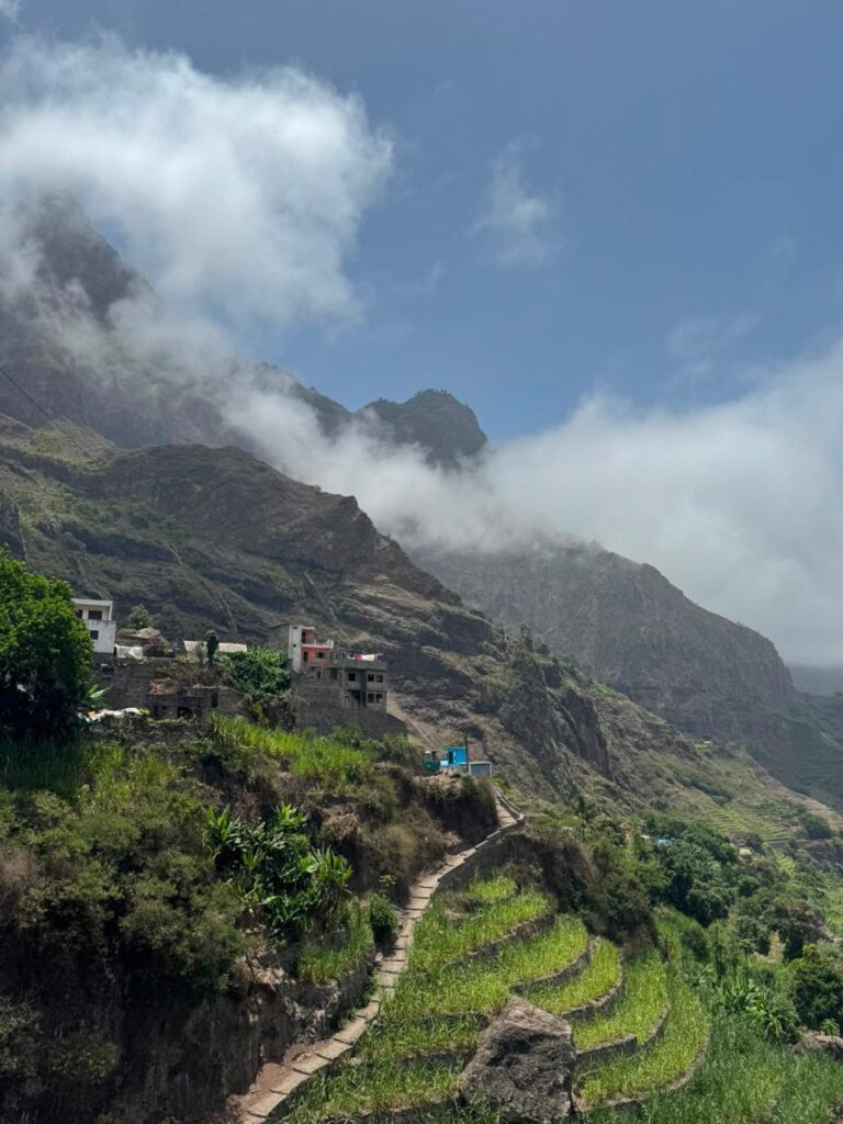
1. Cova to Paul — The Classic Santo Antão Hike
For a first visit, Cova to Paul is one of the strongest introductions to Santo Antão.
The hike begins high in the interior around the volcanic crater of Cova.
The official PR1 SAPL – Route of the Valley starts at Miradouro da Cova and descends towards Cabo de Ribeira.
For the official section, plan approximately:
5–6 km
around 2.5 hours
linear route
Many itineraries continue farther through Paul Valley, which can extend the walk to three, four or even five hours depending on the endpoint, lunch stop and road transfer.
That is why different maps and tours can show very different distances for a route all described simply as “Cova–Paul”.
What Makes Cova to Paul Special
The hike begins in the volcanic landscape around the Cova crater before reaching the rim above Paul.
From there, the view opens across one of Santo Antão’s deepest and greenest valleys.
The old stone path descends through:
- agricultural terraces;
- sugar cane;
- banana and papaya;
- coffee;
- small farming communities;
- steep volcanic walls.
The transition from high mountain terrain to cultivated valley is one of the strongest features of the route.
The Descent Is the Main Physical Challenge
Cova to Paul is usually considered a moderate hike, but much of the route is downhill.
Long sections of stone and cobbled path can be tiring on knees and ankles.
Good walking shoes with grip are important.
Walking poles can also help if long descents normally affect your knees.
Extend the Day through Paul Valley
The official trail section can finish relatively early.
A longer hiking day might continue as:
Cova → Cabo de Ribeira → Paul Valley → local lunch → Cidade das Pombas
This gives you more time in the agricultural landscape after the mountain descent.
Add the Cova–Paul Hike to My Santo Antão Trip
We can organise trailhead transport, a local guide if wanted, onward transfer and a shorter or longer version according to your hiking level and itinerary.
2. Ponta do Sol to Fontainhas and Cruzinha — The Classic Coastal Trail
The north-coast trail from Ponta do Sol to Cruzinha is one of Santo Antão’s signature hikes.
The route passes through:
Ponta do Sol → Fontainhas → Corvo → Formiguinhas → Aranhas → Cruzinha
Plan approximately:
14–15 km
around 6 hours
linear route
The trail combines steep coastal slopes, small villages and repeated views over the Atlantic.
Much of the route follows old paths cut into the mountains above the sea.
A Shorter Version to Fontainhas
For a shorter coastal walk, turn around at Fontainhas.
A practical option is:
Ponta do Sol → Fontainhas → Ponta do Sol
Plan around 5 km return and roughly 2 hours of walking, depending on pace and stops.
This shorter version suits travellers who:
- have only a morning;
- want the coastal scenery without a six-hour traverse;
- prefer an easier transport day;
- want flexibility if weather or energy levels change.
Fontainhas itself is one of Santo Antão’s most photographed villages, set dramatically above the coast.
Continuing to Cruzinha
Beyond Fontainhas, the route becomes a committed one-way hike.
The trail crosses small settlements and valleys before reaching Cruzinha.
Several sections traverse steep coastal slopes.
It is a walking trail rather than a technical climbing route, but exposure can feel significant if you are uncomfortable with heights.
Good footwear matters, and return transport from Cruzinha should ideally be arranged before you begin.
Plan My Ponta do Sol–Cruzinha Coastal Hike
We can organise the full coastal traverse, a local guide and return transport, or build the shorter Fontainhas version into your day.
3. Pedra Rachada to Xôxô — Highlands to Ribeira da Torre
Ribeira da Torre offers another side of Santo Antão’s mountain landscape.
A documented route starts around Pedra Rachada and descends through:
Rabo Curto → Lombo de Pico → Xôxô → Ribeira da Torre
Plan approximately:
6 km
around 3 hours
The route begins in higher terrain before descending towards the greener valley.
That creates a strong change of scenery within a relatively compact hiking day.
Why Hike Ribeira da Torre
This area suits travellers looking for:
- mountain landscapes;
- agricultural terraces;
- smaller rural settlements;
- fewer famous viewpoints than Cova–Paul or Fontainhas;
- time in Xôxô and Ribeira da Torre after the hike.
Ribeira da Torre forms part of the protected Cova–Ribeira da Torre–Paul landscape, an important area for mountain agriculture and endemic vegetation.
Several routes and variants are possible in this valley.
A local guide can be useful if you want to go beyond the straightforward documented trail or connect several paths.
4. Pico da Cruz to Ribeira de Janela — Highlands, Forest and Ocean
The PR2 SAPL, commonly associated with the Rota da Bruxa, begins around Pico da Cruz and descends towards Ribeira de Janela and Ribeira do Penedo.
Plan approximately:
about 9 km
3–3.5 hours
The documented route follows:
Pico da Cruz → Lombo de Tampa → Fajã de Janela → Ribeira de Janela → Penedo
Around Pico da Cruz, the trail passes through higher vegetation and forest before opening towards deep valleys and the Atlantic.
Natural viewpoints along the way look across Ribeira de Janela and towards the coast.
A Strong Third Hiking Day
Cova–Paul and the Fontainhas coastal trail receive most of the attention on first visits.
Pico da Cruz adds highland vegetation and a long descent towards the sea, creating good contrast with those two classics.
It is particularly useful in a three- or four-day hiking programme where each day should bring a new landscape.
Transport needs planning because the start and finish are in different places.
5. Boca de Ambas Ribeiras to Chã de Igreja — Rural Santo Antão
The route between Boca de Ambas Ribeiras and Chã de Igreja crosses the Mocho area and connects several rural landscapes in Ribeira Grande municipality.
Plan approximately:
about 8 km
4–4.5 hours
The effort changes depending on the direction of travel because the route includes long and steep slopes.
Direction should therefore be chosen as part of the hiking plan rather than decided casually on the morning of the walk.
This route suits travellers who already know the two classic hikes and want to go deeper into Santo Antão’s rural trail network.
Expect:
- quieter paths;
- agricultural landscapes;
- small settlements;
- mountain slopes;
- fewer famous photo stops.
Chã de Igreja also has road access, which helps with onward transport.
6. Topo da Coroa — Santo Antão’s Western Summit
Topo da Coroa is the highest point on Santo Antão at approximately 1,979 metres.
It rises in the dry northwest within the protected Parque Natural de Topo da Coroa.
The landscape here contrasts strongly with the green valleys of Paul and Ribeira da Torre.
Expect open volcanic slopes, drier terrain, sparse vegetation and a greater sense of remoteness.
A common approach starts around Chã de Feijoal.
The exact route varies, but a return summit hike is commonly in the range of:
roughly 12–15 km
around 5–6 hours or more
depending on the start point, route, pace and conditions.
Use a Local Guide for Topo da Coroa
Topo da Coroa is the most remote and exposed hike in this selection.
A knowledgeable local guide is strongly recommended if you are unfamiliar with the western trail network.
Route choice, navigation, heat, water and transport all need more attention here than on the classic northeastern hikes.
Start early.
Carry the water you expect to need rather than assuming you can refill along the trail.
Bring food, sun protection and clothing suitable for changing highland conditions.
Experienced hikers may find the summit day straightforward in good weather, but the remoteness and dry terrain justify careful preparation.
Choosing Your Santo Antão Hikes
For a first trip, Cova–Paul and the Ponta do Sol coastal trail provide the strongest contrast.
One descends from volcanic highlands into a cultivated tropical valley.
The other follows old paths across exposed cliffs and villages above the Atlantic.
With a third hiking day, add Ribeira da Torre / Xôxô or Pico da Cruz.
Both take you beyond the two famous classics and introduce quieter mountain landscapes, highland vegetation and smaller settlements.
Boca de Ambas Ribeiras → Chã de Igreja fits well into a longer hiking programme once you want to explore deeper into the rural trail network.
Topo da Coroa belongs in an itinerary focused on the drier western highlands and summit terrain.
You can also shorten individual days.
The Fontainhas return hike, shorter Paul Valley walks and village routes give useful flexibility between longer descents.
Where to Stay for Hiking in Santo Antão
For most hiking trips, Paul, Ribeira Grande and Ponta do Sol are the most useful bases.
Paul puts you close to the classic valley landscape and makes Cova–Paul and local valley walks especially convenient.
Ribeira Grande offers a flexible central position for Ribeira da Torre, northern valleys and access towards Ponta do Sol.
Ponta do Sol is the most convenient base for Fontainhas and the classic north-coast trail.
Porto Novo is excellent for ferry logistics and western routes but adds road time to many of the classic hikes in the greener northeast.
Changing accommodation every night is usually unnecessary. Two well-chosen bases can reduce transfer time while still giving access to several hiking areas.
See our Santo Antão Travel Guide and Where to Stay in Cape Verde when choosing accommodation.
How Many Hiking Days to Plan
Three full hiking days already create a strong Santo Antão trip.
For example:
Day 1 — Cova → Paul
Mountain-to-valley descent and agricultural landscape.
Day 2 — Ponta do Sol → Fontainhas → Cruzinha
Coastal cliffs and villages.
Day 3 — Ribeira da Torre / Xôxô or Pico da Cruz
A third landscape, away from the two classic routes.
With four or five hiking days, you can add:
- a shorter Paul Valley walk;
- Boca de Ambas Ribeiras → Chã de Igreja;
- another highland route;
- a flexible weather or rest day;
- Topo da Coroa if experience and conditions are appropriate.
Mix longer hiking days with shorter walks.
Repeated cobbled descents accumulate quickly in the legs, while a lighter day leaves more time for villages, food, swimming or simply enjoying the valley after the walk.
Hiking Logistics Matter as Much as Distance
Many Santo Antão trails are linear.
That means the hiking day includes two road journeys:
accommodation → trailhead
and:
trail finish → accommodation
A three-hour trail can therefore occupy much more than three hours of the day.
Before confirming a route, check:
- exact start point;
- exact endpoint;
- transfer time to the trailhead;
- return transport;
- realistic availability of an aluguer;
- daylight;
- current trail conditions;
- expected weather.
Pre-arranged transport is especially useful on one-way coastal and mountain routes.
See How to Get to Santo Antão from São Vicente for the complete journey from Mindelo to your accommodation.
If you are spending time in São Vicente before or after the ferry, see our Mindelo Travel Guide.
Guide or Independent Hiking
Several classic Santo Antão paths are well established and experienced hikers may be comfortable walking them independently.
A guide adds more value when:
- the route is remote;
- navigation is unclear;
- several variants are possible;
- weather may influence route choice;
- you want context on agriculture, villages and local history;
- transport needs coordination;
- you are hiking Topo da Coroa.
A local guide also makes it easier to adapt the day when trail conditions, weather or energy levels suggest another route.
For a first visit, one practical approach is to guide the more complex or remote hikes and keep a shorter, straightforward route independent.
Current Trail Conditions and Rehabilitation
Santo Antão’s historic paths are working routes as well as hiking trails.
Stone paving, retaining walls and mountain paths are affected by weather, erosion and regular use.
Trail rehabilitation and signage projects have been taking place across the island, and additional sections continued to enter rehabilitation programmes during 2026.
This improves the trail network over time, but local conditions can still change.
Before setting out:
- ask locally about the route;
- check whether rehabilitation affects access;
- reconsider exposed or steep paths after heavy rain;
- use recent information alongside any GPX track.
An older GPS file may still follow the correct mountain line while missing a recent closure, diversion or damaged section.
Best Time and Weather for Hiking Santo Antão
Santo Antão can be hiked during much of the year.
The drier months generally make trail conditions easier, especially on steep cobbled descents and exposed mountain paths.
Rain is concentrated mainly from August to October, with September typically among the wetter periods.
The greener months can produce spectacular landscapes, but rainfall may make stone paths slippery and can affect roads or trails.
Conditions also vary greatly across the island on the same day.
High ground around Cova and Pico da Cruz can be cloudy, windy and considerably cooler while the coast remains warm.
The western side around Topo da Coroa is generally drier and more exposed.
For a multi-day hiking trip, keep enough flexibility to move a coastal route, valley walk or higher trail according to the forecast and local conditions.
Shoes, Water and Hiking Preparation
Most classic Santo Antão routes are walking trails rather than technical mountaineering, but the terrain can still be demanding.
Expect combinations of:
- stone paths;
- cobbles;
- steep descents;
- uneven steps;
- loose volcanic ground;
- exposed coastal sections;
- strong sun;
- cooler or cloudier highlands.
Wear shoes with good grip.
Carry enough water for the walk and additional time if transport is delayed.
On remote routes, take the water you expect to need rather than relying on refill points.
Sun protection remains important even when the morning begins under cloud.
For longer routes, carry food or confirm where a meal is realistically available.
If hiking independently, download offline navigation before leaving your accommodation.
Getting to Santo Antão for Hiking
Santo Antão has no passenger airport.
The usual journey is:
São Vicente → Mindelo ferry terminal → ferry → Porto Novo → road transfer to your accommodation
Most hiking trips continue from Porto Novo towards Paul, Ribeira Grande or Ponta do Sol.
For a detailed connection guide, see How to Get to Santo Antão from São Vicente.
For current ferry planning, see Cape Verde Ferries.
If São Vicente is also part of the trip, see:
Things to Do in São Vicente Beyond Mindelo
São Vicente + Santo Antão: 7-Day Itinerary
Combine Santo Antão with Other Hiking in Cape Verde
Santo Antão has the deepest concentration of hiking routes in Cape Verde, but other islands add contrasting landscapes.
Fogo brings exposed lava fields, Chã das Caldeiras and the summit of Pico do Fogo.
Santiago offers mountain walking around Serra Malagueta and rural interior landscapes.
São Vicente has shorter volcanic and coastal walks that fit easily around time in Mindelo.
See Hiking in Cape Verde for the wider picture.
Plan Your Santo Antão Hiking Trip
A strong Santo Antão hiking trip is built around variety.
One day can descend from the Cova crater into the agricultural landscape of Paul.
The next can follow old coastal paths through Fontainhas and small villages above the Atlantic.
Another can move through Ribeira da Torre, highland vegetation or a quieter rural valley.
Experienced hikers can add Topo da Coroa for a remote summit day in the dry western highlands.
Tell us:
- your travel dates;
- number of hiking days;
- hiking experience;
- preferred daily duration;
- whether steep descents affect your knees;
- comfort with exposed coastal paths and heights;
- accommodation, if already booked;
- whether you prefer guided or independent hikes;
- whether you are combining Santo Antão with São Vicente.
We can organise accommodation, ferry connections, trailhead transfers, return transport, local hiking guides and a hiking programme adapted to your pace and preferred landscapes.